Thursday, December 15, 2011

Final Blog: The Evolution of a Coastal Volcano

In order to analyze the meteorological evolution of Augustine Island, Alaska, it is also important to understand the dynamic geology that is not only characteristic of volcanoes but of coastal Alaska in general. Volcanoes actually enabled the atmosphere we have today from outgassing, or the emission of dissolved gasses from molten rocks.  With our range of 100 million years into the past and future, it is difficult to theorize about the weather of Augustine because it did not exist 100 million years ago.  Alaska is essentially a compilation of drifting tectonic plates from Asia and other locations of the Pacific, which is why it is riddled with the Archipelagos and beautiful fjords.  The geology of coastal Alaska is difficult to map because of this, as there are many types of rock that clearly came from different locations. 


The above images show the original collison of Alaska, then part of Eastern Asia, with the North American Plate.  It is this collision that essentially dictated and continues to play an important role in the topography and climate of the Aleutian Range and South Central Alaska.  To begin, we will look at the current geography of Augustine Island as well as the current climagraph to serve as a reference for the hypothesized past and
 future projections. 


 Augustine is indicated by the red dot in the Kachemak Bay/Cook Inlet area of South Central Alaska, and sits at 59 degrees 21' 48" N, & 153 degrees 26' 00" W. As discussed previously, this location experiences a maritime climate and is subject to the Aleutian Low in the winter, and just on the edge of the Pacific High in the summer. This makes it susceptable to winter mid latitude cyclones, which are nearly equivelant to hurricanes in tropical climates.  Below is a climagraph that represents the average temperature and precipitation for the bay area where Augustine is located.

http://climate.gi.alaska.edu/climate/Climographs/ADQ.html

Again, the temperature in the summer months rarely reaches above 70, and can be freezing throughout the winter.  This is a relatively extreme change in temperature that much of the 30 degree-60 degree North latitude zone experiences.  Not only is this influenced by the pressure systems, but the latitude gives it an extremely low angle of illumination by the sun in the winter and therefore contributes to the low winter temperatures.  With that in mind, we can begin to understand how millions of years ago a somewhat different climate existed. Below is an image of how earths continental plates looked approximately 105 million years ago, in the Cretaceous Period of the Mesozoic Era, "The Age of Reptiles".

Much of what scientists hypothesize about Alaska's climate 100 million years ago is based on geologic discoveries.  For example, plant fossils were discovered that suggested Alaska's climate would have been similar to present day Northern California, Oregon, & Washington.  Below is what a climagraph may have looked like for that time period. As the graph illustrates, temperatures were warmer at that time and were slightly closer to maritime tropical than todays cooler climate.  The precipitation remains high in the late summer months and early fall, and is fairly consistent throughout the year, as it is today.  This would correlate with the explosion of flowering plants on earth and the thriving of reptiles.  Although, unlike today, Augustine would not have experienced the orographic protection of the Aleutian Range as the Islands are not fully merged with the North American Continent, therefore leaving the eastern side of the Aleutians vulnerable at this point in time. 
Despite not having the topographic protection of being in a bay as the island is today, the climate was clearly much more mild and so it would not have been subject to the winter cyclones.  In addition, it would have received more precipitation throughout the year because unlike today, it would have been apart of the Aleutian Chain instead of lying to the east and receiving protection.


Although it is difficult to discern from the image, what used to be Augustine Island would most likely be part of the inland topography 100 million years from now.  There are many patterns in the geologic history our earth, some of which we have discussed, that support this hypothesis.  First, the U.S.G.S. puts Augustine Island at a slightly higher latitude in the Pleistocene Epoch, which when compared to the location of the developing Aleutian Archipelago in the Cretaceous Period, this shows that the island is moving north.  If this continued, and as it appears on the projection map, the island will eventually become part of the mountain range in the mainland.  This will transition Augustine from having a coastal maritime climate to a continental climate, lacking the moist, oceanic influence that it received for millions of years. Based on this theory, below is a climagraph that may represent Augustine's location in the distant future.


As the graph illustrates, it will now be influenced by a Continental Air Mass, much more dry than the Aleutian Low that originates over the North Pacific.  In addition, the average winter temperatures will be much colder as the latitude will have had increased much more significantly.  The winter months will therefore receive even less light from the sun, coupled with the reduced moisture to hold in warmth, the climate of Augustine is becoming more like the Arctic than the Pacific Northwest. It is even possible that this area could be covered in ice, if the earths pattern of glaciation continued. To gain a more photographic perspective of this interesting transition from 100 million years ago to 100 million years into the future, below is a series of photographs from each of the three time periods. 


100 Million Years Ago-Pre Augustine Island


Present: Augustine Volcanoe


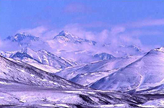
100 Million Years From Now: Part of the Interior Mountain Range

Although we have an idea of how the earth has evolved and will evolve, as well as recent data on temperature and global weather changes, the earths dynamic nature makes it difficult to be sure about theories stretching 100 million years into the future. There is still much to be learned about the geologic past of earth, and science will need to evolve as we uncover more.  It is difficult to predict the local weather of the front range, let alone 100 million years into the future, however in making an attempt to do so we can learn much about the way our atmosphere and pressure systems influence the climates of our planet.

Additional Sources:

Tarbuck, Lutgens, Tasa. Earth: An Introduction To Physical Geology. Tenth Edition.
                2011. Pearson. New Jersey.


Monday, December 12, 2011

Alaska vs. Costa Rica

For this reflection I chose to do Nicoya, Costa Rica.  Comparing this location not only has meaning for me because Costa Rica is one of my favorite countries but also because comparing it to the colder, maritime climate of Augustine Island, Alaska is interesting in that they are both relatively moist climates, however one is relatively cold and one is tropical. To start, it is easy to compare the climates by analyzing climagraphs from each location. Below is the climagraph for Alaska, followed by Costa Rica. 

Mean monthly maximum and minimum temperature and total precipitation
for the period 1971 - 2000.
http://climate.gi.alaska.edu/climate/Climographs/ANC.html

Clearly, the average temperatures for South Central Alaska rarely reach 70 for just a short couple months out of the year.  The rest of the year remains relatively cool to freezing.  This is due to the maritime climate.  This, along with the latitude, contribute to the cooler summer months so that Alaska never sees extreme heat in the summer. 


Nicoya's climagraph tells quite a different story. It is apparent right away that there are much larger temperature variations because of the extremely hot temperatures Costa Rica receives in the summer months.  The high temperatures correspond to the dry season, while lower temperatures occur in the wet season where, being a tropical climate, they receive a great deal of rainfall. It is these vast differences in yearly temperature as well as periods of greatest precipitation that make these two places so interesting to compare.  Below are contrasting images of the location that illustrate what the climagraphs portray.


Friday, December 2, 2011

According to the Koppen/Gieger Climate Chart, Augustine Island is classified as a Dfc. D meaning snow, f meaning fully humid, and c meaning cool summer. This is characteristic of a majority of the 50-70 degree latitude locations. In analyzing the micro and meso scales of climate controls for Augustine Island, I thought it would be interesting to look at the trend in wave heights around the area, as it could be an indicator of weather at my location.  Below is a graphical sequence of wave heights for Kachemak Bay and the Gulf of Alaska, with the first picture showing a broader view, followed by a zoomed sequence to show greater detail. Augustine Island is indicated by the small red dot.


It is clear that during times of increasing wave height in the Gulf of Alaska, the wave heights surrounding Augustine Island are not affected as it is geographically protected by the Kenai Peninsula, Kodiak Island, as well as the Aleutian Range.  It is because of the geographic location that the island experiences an orographic effect and is essentially protected by this, giving it and the surrounding area a relatively stable seasonal variation relative to most parts of Alaska. Because of the protection provided by the topography, in addition to the maritime climate, the summers stay relatively cool, and the winters can be extremely cold but much of the weather is shielded by the Aleutian Range.  This allows the Boreal forest and Temperate rainforests to survive along the coasts in this area, wheras on the western coast of Alaska that is not protected by such topography is mainly tundra and exposed to the feirce weather coming from the Northern Pacific. Aside from the geographic location, the weather around Augustine Island can be affected by other elements as well.  The most obvious being that the island is a volcanoe.  By looking at the current data from weather underground, and comparing it to the data at the time of its last eruption in 2006, it is possible to see how the volcano manipulates the surrounding atmosphere. Below are the contrasting graphs, January of 2011 on the left and January 2006 on the right, as well as a thermal satellite image of an actual eruption from the volcano.


Photo courtesy of Wikipedia-Augustin Eruptions

The air pressure of the island is significantly different during a volcanic eruption as can be seen from the Barometric Charts.


Tuesday, November 15, 2011

Perhaps the best way to understand weather in a certain location is to compare it with another. At roughly 59 degrees N and 153 degrees W, Augustine Island, Ak is located at a latitude where the subpolar lows meet the westerlies, and lies almost directly in the Aleutian Low in the winter, and affected by the Pacific High in the summer. Contrarily, Dublin, Ireland, is located slightly below Augustine on the latitude spectrum at 53 degrees N and 6 degrees W longitude. These coordinates put it in an interesting location, in between the Icelandic Low and Azores High in the winter, and largely affected by the Bermuda High in the summer. Below gives a visual contrast of each location in winter. Augustine appears to look mild with its clear skies, however in the winter clear skies can be bitter cold in Alaska. When it is not in the middle of a mid-latitude cyclone, clear skies indicate cold weather. Dublin does not experience the extreme temperature changes because of its lower latitude in that instead it is dominated by the westerlies and high pressure systems which keep the climate relatively mild. Although they are both influenced by maritime systems that create rather moist and dreary climates, Mount Augustine is slightly further north and is further from the Pacific High, so it experiences the extreme cold in the winter that Dublin is not impacted by.

www.bostonphoto.com

www.flickr/people/jogorman/

Tuesday, November 1, 2011


Picture taken from the National Oceanic Atmospheric Administration
http://pafc.arh.noaa.gov/tvwx.php?img=tomorrow

As stated previously, Augustine Island is located in an air mass known as the Aleution Low, a semi-permanent Polar Air Mass that is characteristic of the Arctic region, although Augustine is further south from the Arctic Circle, it is still part of this air mass. As a result of this, places in the Aleution Low are almost constantly hit by low pressure mid-latitude cyclones that originiate in the North Pacific during the winter. On Tuesdays weather map, this is illustrated as the cold front that made its way from northeast Asia begins to occlude the maritime polar warm front, creating the midlatitude cyclone, which today produced snow around much of the low pressure system.


A picture of a low pressure winter system from the NASA Earth Observatory in the Gulf of Alaska really encompasses the term Mid-Latitude Cyclone.


Picture by Ian Shive

Above is the Aleutian Range shown at sunset. This range makes up the Aleutain Archipelago and extends into the Alaska Range as it makes its way inland. Like Denver, which lies east of the Rockies, Kachemak Bay(Augustine Island) and the Cook Inlet often experience clear skies when the Aleutian Range to the west is receiving snow. This is apparent in the weather map above. This location is interesting because it is affected by mountian ranges, the Bering Sea, and Continental and Oceanic Air Masses which are both frigid and mild.

Tuesday, October 18, 2011

Augustine Island is essentially a lava dome complex that creates an island located in the Cook Inlet, Alaska, in the Kenai Peninsula Borough. It is one of the most active volcanos in  Aleutian Arc. Its most recent eruptions were in 1883,1986, and in 2006, as shown in the picture below. The volcanic ash plume can be seen in almost the very center.

Located just outside the heart of the Aleutian Low at 59.378 N 153.348 W, it is therefore is subject to the almost permanent low pressure systems that circulate in the North Pacific. 
NASA image created by Jesse Allen, Earth Observatory

Photo by Bill McGuire

Shown below is a chart from the AUGA2 Station on Mount Augustine,  taken from the National Data Buoy Center. It shows, in Degrees Celsius, the average and standard deviation of monthly temperatures throughout the year. 
The climate of the Mount Augustine is a maritime climate and is therefore rather wet from the warm air over the Pacific, however stays relatively cool in the summer and can be extremely cold in the winter, as seen above, due the the Aleutian low pressure system.